Project Highlights
- The Atocha project is located in the Municipality of Falan, in Tolima (Colombia), some 190 km west of the capital, Bogota. The property elevation ranges from 700 to 1,100 metres (2,300 – 3,600 feet) and is accessible by a paved road from Mariquita and by a network of rural (unpaved) roads.
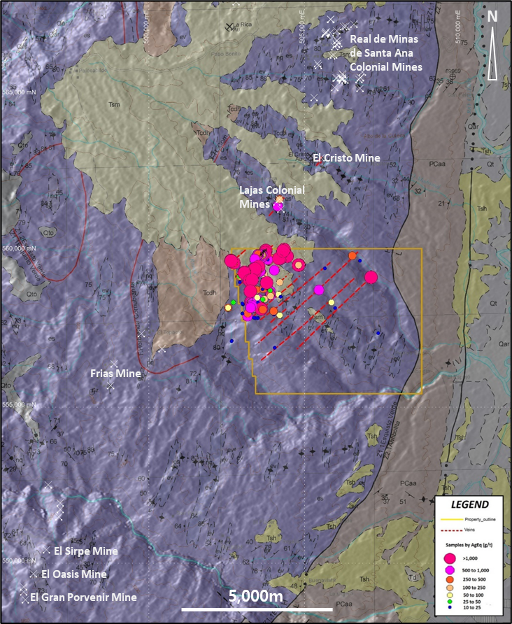
- The project area is located within the historic colonial Santa Ana-Frías-Mariquita Silver District, which is the highest-grade primary silver district in Colombia, and has seen no previous colonial or modern exploration on it.
- There is an exceptional geologic setting which translates into very favourable regional structures throughout the property (the “Atocha Corridor”), resulting in clusters of very high vein densities with a vast number of high-grade primarily silver (and gold) showings exposed right at surface within the property area. There are +30 km cumulative strike length of silver-gold bearing veins identified from just surface exposures.
- La Ye vein zone demonstrated the existence of a major structural deformation corridor with a wide associated multiple vein system. The primary vein system at La Ye is comprised of at least 6 major veins and several smaller associated parallel veins covering a strike length in excess of 500m, open in both directions.
- Phase 1 drill program at La Ye consisted of 1,700m in 13 drillholes covering 300m of strike length, open to the Southwest and at depth.
Overview
Property Location
- The project is located in the Municipality of Falan in northern Tolima (Colombia), some 190 km west of the capital, Bogota, and the property elevation ranges from 700 to 1,100 metres (2,300 – 3,600 feet).
- Favorable access to the project area is afforded by a paved road from Mariquita to the east, westwards to the town of Falan, 990 m. a.s.l., and thence by a network of rural (unpaved) roads south to the property. Alternatively, the project is also easily accessible from Armero-Guayabal via several unpaved roads to the northwest, off Route 43, the Ibagué Highway.
Geology
The Cajamarca Complex, which consists of highly deformed gneisses and schists, meta-intrusions and basement gneisses underlies the Atocha project. The project also contains later Cenozoic supra-crustal rocks and deposits, and is intruded by plutons and stocks of various ages including the Cretaceous – Eocene age El Hatillo and Mariquita stocks. A narrow, north-south trending sequence of Grenvillian gneiss and schist (grey), the Chicamocha gneisses, forms the eastern boundary of the property.
Gold-silver mineralization is located within the Palestina (NW), Otú-Pericos (East) and the North-South trending Mulatos fault. Mineralisation at the Atocha project appears to be modified more by the late, Mesozoic, Cretaceous to Miocene age, brittle faulting, with mineralised veins usually hosted by north-east trending, sub-vertically to steeply east-dipping normal and reverse faults. The main mineralization may retain the postulated early phase of orogenic-related mineralization, but it should be emphasised that the area has a locally significant epithermal overprint.
Overall, veins in the district are hosted by sub-parallel, oblique-slip normal faults and extension fractures striking between 030° and 060° and dip moderately to steeply north-west. These fault orientations host some of the richest veins of the district, including La Ye, Veta Grande, NW Veins, Tavera-Guadua and the recently discovered El Erizo vein.
Vein textures include crustiform banding, breccias, and cockade textures, suggesting that vein opening and filling was episodic, with several episodes of fault movement related to brecciation and mineralization. Veins in the district are hosted by folded, metamorphosed Palæozoic schists (basement) and are generally narrow, and locally anastomosing, with anomalous silver grades (<5 oz/t Ag) or small zones of high-grade ore (>15 oz/t Ag). It has been observed that for some veins (e.g., NW Vein, Veta Grande W, and elsewhere, e.g. around Santa Ana-Falan), significant mineralisation (taken as >50 oz/t Ag) was present near E-W trending aplite-diorite stocks.
The lineament pattern for the area covering the Atocha project, is based on satellite and photographic interpretation and limited prospecting and geological investigations. Postulated mineralised veins discovered during the prospecting are shown in red and coincide with a regional marked structure that seems to be controlling the Silver-Gold mineralization in the property, and we refer to it as the “Atocha Corridor”. Precise trends and strike extent are inferred due to the exploratory nature of past work, but much of Atocha property remains unexplored.
Elongate intrusions such as the 53 ± 1.8 Ma (Paleocene – Eocene) El Hatillo stock crop out along the NW side of the property and the spatial relationship between the Santa Isabel and El Hatillo stocks and vein (gold) mineralisation is well known, with some areas currently being developed and in production as small mining operations.
Work Performed
La Ye vein zone demonstrated the existence of a major structural deformation corridor with a wide associated multiple vein system. The primary vein system at La Ye is comprised of at least 6 major veins and several smaller associated parallel veins covering a strike length in excess of 500m, open in both directions. Mapping has been possible due to the existence of a vast number of exposures and outcrop occurrences and the first batch of rock chips collected in Q2-2021 at outcrops and sub-outcrops average 182 g/t Ag (or 304.4 AgEq).
Baroyeca has drilled thirteen holes at the La Ye target for a total of approximately 1,700m as part of an ongoing drill program which has to date covered approximately 300m of strike length of the vein corridor from its north-easternmost end, where the vein system ends abruptly against a fault zone just outside the property boundary and remains open to the southwest and at depth. Drilling was intended to test only the shallowest part of the vein corridor with approximately 25 meters step outs to identify and delineate a high-grade silver and gold mineralized zone or shoot near surface at La Ye. This will be followed-up at depth in future delineation drilling campaigns once the Company identifies and prioritizes other high-grade mineralized zones in different vein sets throughout the property.
The first holes drilled on Atocha targeted the La Ye vein system and successfully identified and delineated the first mineralized zone. In those initial 13 drill holes, Baroyeca hit a series of high-grade intercepts including 2,233g/t AgEq over 0.80m, 1,137g/t AgEq over 0.50m and 981g/t AgEq over 0.40m and encountered more than 25 intercepts returning over 200g/t AgEq at La Ye, with a weighted average grade of 570g/t AgEq (7.6 AuEq g/t) over an average intercept width of 0.50 metres. The drilling to date has tested 300m along strike to shallow depths in small step outs, demonstrating the continuity of the silver and gold mineralization and the consistency of high grades across a growing vein system.
Drilling Results
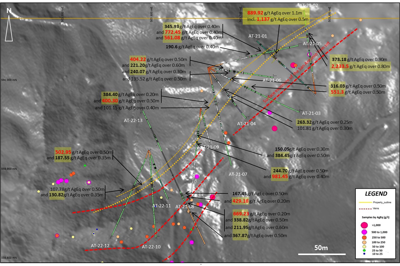
| Hole # | From (m) | To (m) | Interval (*) | Au ppm | Ag ppm | AgEq ppm |
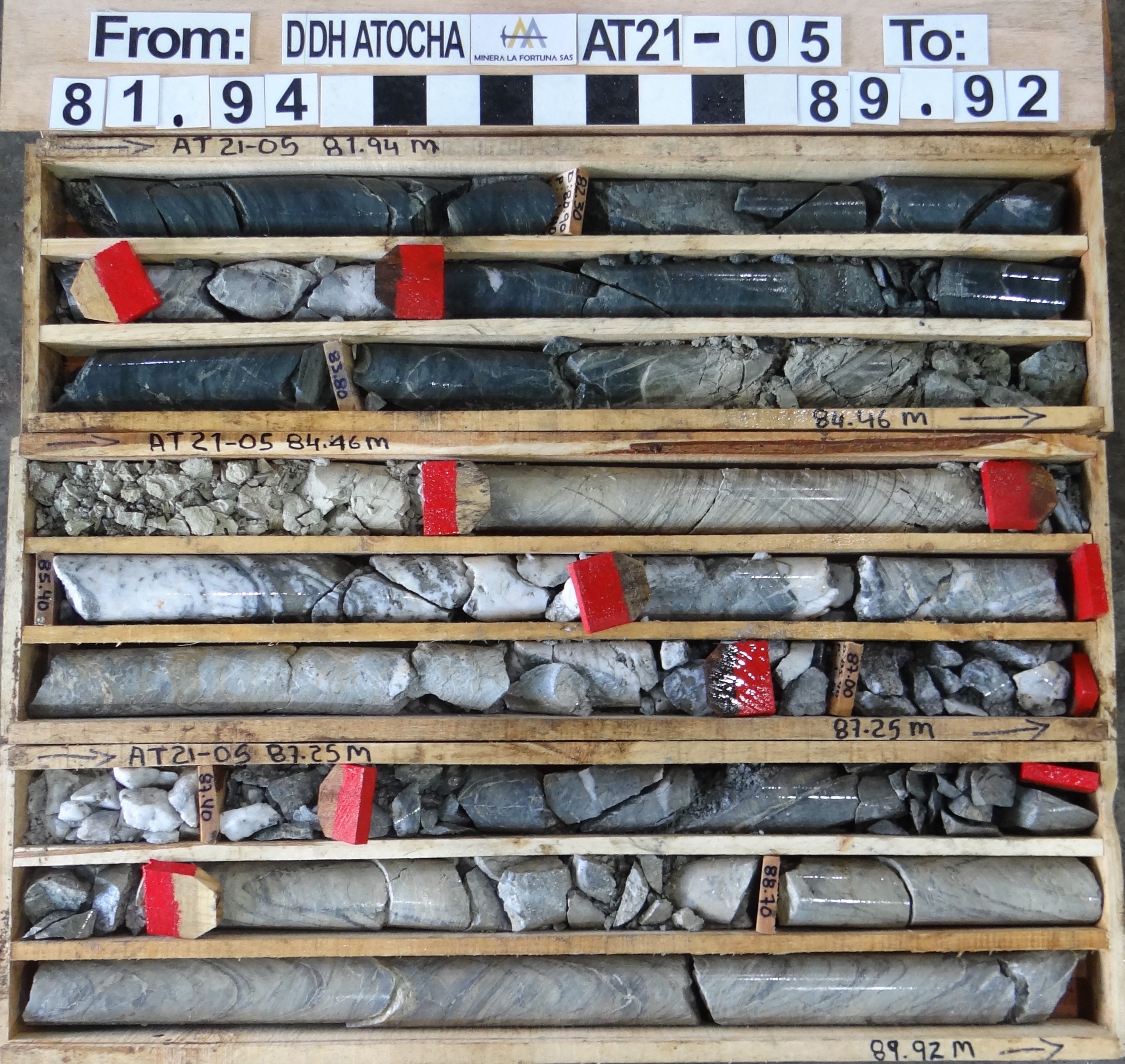
| AT-21-01 | 84.00 | 84.50 | 0.50 | 13.11 | 153.8 | 1,137.05 |
| 84.50 | 85.10 | 0.60 | 4.519 | 364 | 702.93 | |
| 87.35 | 87.90 | 0.55 | 1.163 | 24.1 | 111.33 | |
| 87.90 | 88.40 | 0.50 | 2.605 | 17.4 | 212.78 | |
| AT-21-02 | 85.70 | 86.50 | 0.80 | 20.14 | 723 | 2,233.50 |
| 88.10 | 89.00 | 0.90 | 1.289 | 276.5 | 373.18 | |
| AT-21-03 | 38.50 | 39.00 | 0.50 | 0.127 | 306.5 | 316.03 |
| 62.50 | 63.00 | 0.50 | 1.305 | 11.8 | 109.68 | |
| 65.80 | 66.30 | 0.50 | 3.736 | 271.1 | 551.30 | |
| AT-21-04 | 41.30 | 41.55 | 0.25 | 0.176 | 251 | 263.32 |
| 52.80 | 53.10 | 0.30 | 0.379 | 42.2 | 68.73 | |
| 59.20 | 59.40 | 0.20 | 2.047 | 15.6 | 158.89 | |
| 63.32 | 63.62 | 0.30 | 0.373 | 75.7 | 101.81 | |
| AT-21-05 | 67.10 | 67.50 | 0.40 | 1.112 | 107.2 | 190.60 |
| 85.40 | 85.95 | 0.55 | 2.529 | 371.4 | 561.08 | |
| 85.95 | 86.30 | 0.35 | 0.183 | 53.8 | 67.53 | |
| 86.30 | 86.70 | 0.40 | 0.273 | 56.8 | 77.28 | |
| 86.70 | 87.10 | 0.40 | 4.146 | 461.5 | 772.45 | |
| 87.10 | 87.50 | 0.40 | 1.411 | 240.1 | 345.93 | |
| AT-21-06 | 49.50 | 50.00 | 0.50 | 0.908 | 6.4 | 74.50 |
| 50.00 | 50.50 | 0.50 | 3.011 | 178.4 | 404.23 | |
| 60.80 | 61.40 | 0.60 | 0.884 | 154.9 | 221.20 | |
| 62.75 | 63.05 | 0.30 | 1.173 | 152.1 | 240.08 | |
| 82.70 | 83.20 | 0.50 | 1.807 | 127.5 | 135.53 | |
| AT-21-07 | 47.50 | 47.70 | 0.20 | 0.984 | 310.6 | 384.40 |
| 51.70 | 52.20 | 0.50 | 2.084 | 244 | 400.30 | |
| 64.10 | 64.50 | 0.40 | 0.63 | 53.9 | 101.15 |
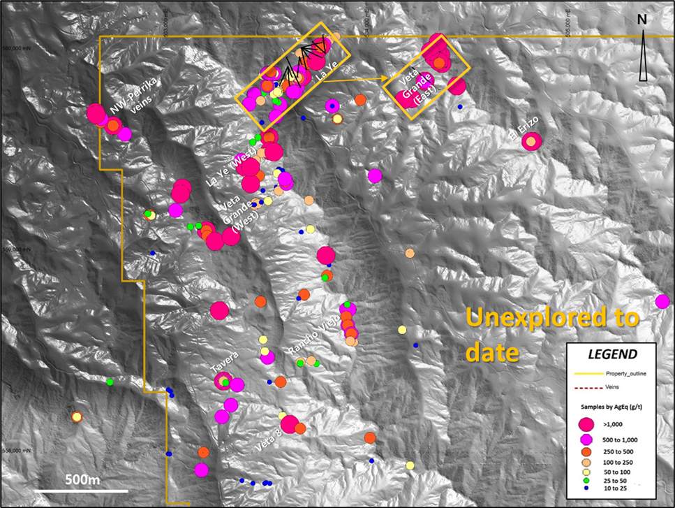
Vein Occurrences and Sampling Results (AgEq) Map
Baroyeca identified two new vein zones named El Erizo vein and Perrika vein in Q4-2020. Rock chip samples at El Erizo vein returned silver values as high as 951, 839, and 691 g/t Ag. Chip samples from Perrika vein returned 5.70 g/t Au and 696 g/t Ag and 6.91 g/t Au and 510 g/t Ag and a parallel El Cucharo vein returned higher gold values (17.59, 15.01 and 10.89 g/t Au) and 217.6, 187.2 and 168.t g/t Ag
A series of sub outcrops were found prospecting along the Tavera-Rancho Grande-Las Guaduas vein system that returned high-grade silver assay results with anomalous gold values (up to 969.3, 726.5 and 658.4 g/t AgEq) in grab samples extending its trend for more than 1km along strike.
Highest gold and silver grades were obtained from previous operator Condor Precious Metals. A series of rock chip samples were taken in three exposures of the Veta Grande vein system and individual samples returned gold values as high as 14.65 g/t Au and 14.20 g/t Au, and highest silver values of 3,480, 2,300, 1,955 and 1,570 g/t Ag. Baroyeca discovered a new outcrop along the vein proving results as high as 14.4 g/t Au and 420 g/t Ag in chip samples from the western extension of the Veta Grande showings and extended an extra 100m the length of the identified high-grade shoot.
The Atocha Project’s potential has only been marginally explored and exposed. The area has never been mined and there are no environmentally or culturally protected areas within the property
History
The Atocha project covers a significant part of the Santa Ana-Frias-Mariquita District where mining records date to at least 1585.
Historically, the region is famous for precious metals extraction by the indigenous people, who extracted native gold from unconsolidated Recent-Quaternary sediments, alluvial sediments and underground mining. Following the Spanish Conquest, more formal mining commenced, with extraction of gold and more importantly, silver specifically around the town of Falan to the North of the project. During the time the Spanish operated the mines, silver grades were reported to be some of the highest in Latin America.
As part of a compilation of abstracts from the Spanish Archives during the Colonial Period between the XV and XVIII Centuries, history recognizes Fernando Silvero to be the first discoverer of the gold and silver mines in Mariquita and Fálan circa 1585, these comprising four veins in the San Juan Bautista hill. In the same year, Captain Diego de Ospina, Matias de Saucedo and Pedro Henriquez mined rich veins in the area. The average smelter return for silver ore during those days was "4 marcos per quintal" (equal to approximately >17kg/ton Ag), according to official reports of Hacienda Santa Fe (year 1585), and reported widths exceeding 1 1/2 varas (4 1/2 feet). Subsequent exploration discovered some more veins in the Santa Ana (today Falan) and Frias regions, adding 14 new mines to the district, all of them producing over one marco of silver per quintal (approximately 4.3kg Ag per ton). D. Antonio González, President of the New Kingdom, described in a summary of the gold and silver mines discovered in the Mariquita and Fálan areas as follows: "these mines exploit three main veins striking North-South and a fourth striking Northeast, with strike lengths over 8 km (1 1/2 castillian leguas)". In a document dated 1640 by Gonzalo de Murillo Velarde and Antonio Gonzalez describing the heyday of the Santa Ana and Lajas mines between the years 1585 and 1620. In 1795 the King of Spain suspended all mining operations in the area due to the financial and material losses from mineral processing, which in part related to conflicts with the Amerindian workforce, the increase of labour costs, and the lack of production from the Spanish themselves.
Spanish mining was superseded by the British, commonly in the form of Cornish migrants who worked their way through Central and subsequently, then Southern America. In 1824 a lease was granted to Herring Graham and Powles from London, UK, but they made little or no profit during the 50 years they were mining the area. The Santa Ana and La Manta leases expired in 1874, and the mine was bought back by the Colombian Government at a very low price, whist discrediting the British mining company’s lack of success in the process. A less than enthusiastic British work ethic in the hot and humid tropical environment and their overall behaviour compounded the company’s woes. The British engineer Robert Stevenson worked briefly in the Falan area, leaving well-preserved old mine workings and reports indicating the relatively extensive underground mine development within and around the town of Falan, and also several kilometres to the South, in a second mining area operated by the British called El Cristo mine, together with another extensive mining infrastructure located at the headwaters of the Jimenez creek, near the northern boundary of the Atocha project.
The last gold-silver rush started in the area in the 1930's, with focus on existing or past producing mines. As a result, 4 mining districts (re)-started: Ibagué, Anzoategui, Santa Isabel and Líbano.
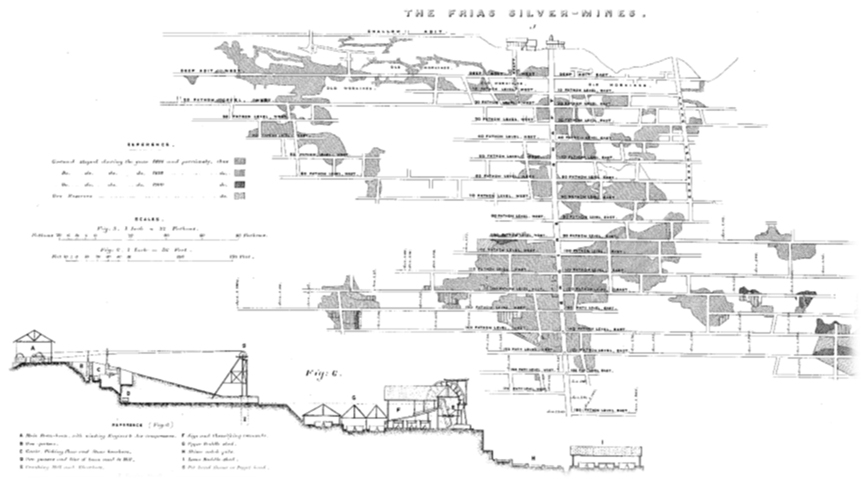
Total production records(*) from Frías mines 1868-1903 was 7.8 Moz of silver (238.7 tons of white metal) with average concentrates exceeding 350 oz/t of silver* (>10.8 Kg Ag per ton)
(*) From Russell on the History and Development of the Frias Mines, Paper No.3309, historic report. Results cannot be verified by company QP.
Qualified Person
The scientific and technical information has been prepared in accordance with the Canadian regulatory requirements set out in National Instrument 43-101 (Standards of Disclosure for Mineral Projects) and reviewed and approved on behalf of the Company by Raul Sanabria, MSc. P.Geo. a Qualified Person as defined by NI 43-101 (the “Qualified Person”).